
|
|
||
|
|
|
|
The Mercator Sailing ProblemBelow is a form using JavaScript that solves the Mercator Sailing problem: Sailing
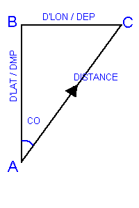
In broad terms, there are two main types of sailing, namely, the Rhumb Line sailing and the Great Circle sailing. The Mercator Sailing is the most accurate method employed in marine navigation to handle calculations related to Rhumb Line sailing. Rhumb LineIt may be difficult to believe that if you sail on a constant course, except on exact East or exact West, you will end up at the North or the South pole, assuming there is no land in between. The constant course track that appears like a spiral on the Earth spheriod is called a Rhumb Line track.Mercator SailingThe plain triangle on the right indicates the plot of a Rhumb Line track on a Mercator chart between two points (A and C). By applying simple trigonometry principles the course and distance between the two positions can be determined.The formulae for determining the values are :- tan course = difference in Longitude / difference in Meridional Parts Further ReadingTools and more info
Misc |
|
|
|
Europe: Port Aleria, Rosnakilly, Kilmeena, Westport, Co. Mayo, Ireland - USA: PO Box 726, Mahwah, NJ 07430 All content on this site is subject to Copyright© - All rights reserved. Contact us - Advertising - Privacy - Terms & Conditions - Copyright & Trademark - Webmaster |
 Sailing is the term used in the maritime world to describe the method used to solve the problem of course and distance between two positions.